Between 2023 to 2025, the Institute of Chinese Studies at The Chinese University of Hong Kong, the École française d’Extrême-Orient, and The Hong Kong University of Science and Technology Library co-organize The Backgrounds of the Chinese Maps: Their Reading and Understanding Public Lecture Series to create new perspectives in map studies through the exchange and cooperation in this field.
Maps are most often communication tools. To enhance our understanding of their significance and use, it is important to have accurate knowledge of the stages of their mapmaking process and of their languages, including the recognition of their codification systems. It is also essential to be aware that maps are, by their very nature, never definitive. They are the result of a particular era, temporal objective, or policy goal that has inevitably changed over time. Our reading of maps must take all these elements into account, and in particular, we must avoid our modern way of looking at things, so that we do not interpret elements and representations that we no longer understand as bizarre.
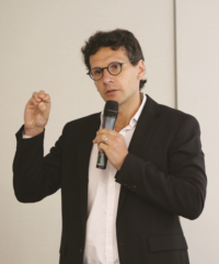
Prof. Radu Leca from Hong Kong Baptist University was invited to deliver the ninth lecture in the series on 30 April 2025, in the Activities Room of the Art Museum East Wing at CUHK. He presented on the topic “Orankai and the Geographical Imaginary of the Qing in Early Modern Japan”. The lecture was conducted in a hybrid format and attracted over a hundred participants from the CUHK community and the public, who contributed insightful feedback and enjoyable discussions. |